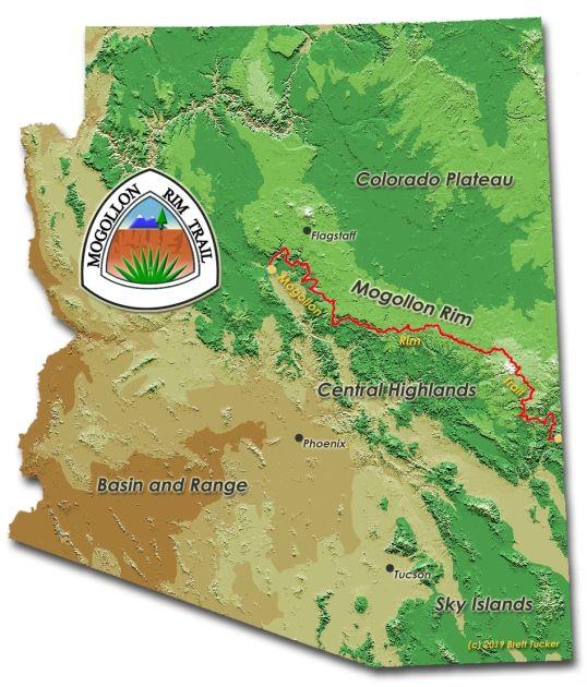
The Mogollon Rim Trail (MRT) is a 503mile / 810km route across the Mogollon Rim in Arizona, and another Brett “Blisterfree” Tucker route. The man is a genius when it comes to designing beautiful hiking routes across arid terrain!
The Mogollon Rim is a physiographic feature that is the boundary between the Colorado Plateau and the lower deserts. The route is a combination of trails and dirt roads, and travels in a west-east direction, ending at the New Mexico state line. It starts in Sedona redrock country, and crosses 4 National Forests, the world’s largest Ponderosa pine forest, the White Mountains, and Blue Mountains Range along the way. From the finish, there is a short connector trail to the town of Alma, NM, where I can continue on the Grand Enchantment Trail (GET) if time and desire allows.
I expect the main challenge of the route will be drinking water; the weather should be quite pleasant in May, though there is significant elevation gain/loss, so I’ll aim to hike the climbs in the cooler morning hours when possible.
The route’s creator, Brett “Blisterfree” Tucker, has a great page with all the info. The trail isn’t a direct route, but rather meanders above and below the Mogollon Rim. Brett’s overview map shows it better than any map I could create:

The hike should take me between 25 and 30 days, as I plan to average 20 miles per day. I’ve known about this route for awhile, ever since 2019 when I hiked another of Brett’s routes, the “Lowest-to- Highest”. After completing the WTH last winter, I decided I needed to spend more time in Arizona, and I moved it up my list!
Daily Blog Posts:
MRT Day 0: Getting to the Start
Day 8 : Creeks are Made for Walkin’
Day 12: Highline Trail, Rough Version
Day 15: Mesas, Mares and Meetings
Day 22: Getting Warmer and Cleaner
Day 24: Bear Wallow Wilderness
GET (Grand Enchantment Trail) posts: