The Hot Springs Trail (HST) is a 2,421mile / 3900km route across the Coast Range and Sierra Nevada Range in California, Great Basin Desert in Nevada, and a variety of mountain ranges in Idaho. It follows a route across mid- to high-elevation mountains and desert valleys of the American west, crossing numerous Wilderness areas, 3 state parks, and 1 National park along the way. The route is a creation of Aria Zoner, who dedicated much time and resources to develop this trail, and he even wrote a guidebook and a website full of planning resources.
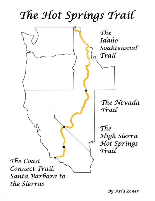
The route is almost entirely on public land, and much of it is on-trail (45%), while the rest is either cross-country (10%) or disused dirt roads (25%), with the remainder on gravel roads or paved roads. It starts at the Pacific Ocean at Stearns Wharf in Santa Barbara, and continues east across the coastal ranges (the “Coast Connect Trail”). The trail enters the Sierra Nevada Mountains at Kernville, following the Kern River for awhile, then continuing north thru Kings Canyon & Sequoia National Parks, before exiting the mountains at Mammoth Lakes, CA (the “High Sierra Hot Springs Trail”). Now in the desert, the trail crosses into Nevada (The “Nevada Trail”) at the highest point on the HST, and Nevada’s highpoint, Boundary Peak (13,147ft / 4007m). After traversing 600 miles of Nevada’s “Basin and Range” terrain, the trail enters Idaho, where it mostly uses the Idaho Centennial Trail for the remainder of it’s journey to Canada.
The main challenges of the route both relate to water – either too much or too little. In the High Sierra section, spring snowmelt will make some of the creeks and rivers challenging to cross; conversely the desert section will have a relative lack of drinking water, where water carries of 30 miles are not uncommon. I plan to start in mid-May, which is a compromise between the Sierra snowpack in early June, and the heat of Nevada deserts in July. Overall, there isn’t much per-mile elevation gain/loss. The highest point is Boundary Peak (13,147ft / 4007m), and the lowest point is sea level at the Pacific Ocean, though much of the trail stays between 3000-5000ft (900-1500m). This map shows the general route of the Hot Springs Trail:
And I’ve also created an overview route in Google Maps (not for navigation!)
The hike should take about 4 months, as I will likely will cover about 20 miles per day, plus some rest days in towns and for resupply. I learned about this trail in 2017 when I was at an ALDHA-West event, and the route’s creator was there giving presentations about it. At that point, I had only hiked two long trails (PCT and CDT) and didn’t feel ready for such a remote and dry hiking experience.
My original hiking plans for 2025 were to travel the Desert Trail with a hiking partner, but after life-got-in-the-way-of-plans, we decided to save the Desert Trail for 2026, though I’ll hike a short section this year to get a taste of it. Then, in early May, I’ll head over to Santa Barbara to start the Hot Springs Trail! I’m looking forward to spending several months exploring the beauty of the desert, and soaking in many of the trail’s 96 hot springs. I’ll document the journey here with daily journals, but due to limited connectivity, I’ll likely only post them when I’m online in towns.
Daily Blog Posts:
Getting to the Hot Springs Trail
Day 1: